
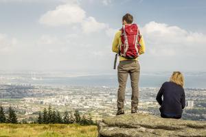
WITH the country in partial lockdown amid the coronavirus pandemic, walking is the new social outlet for many.
fficials are taking precautions with the Covid-19 outbreak in Ireland, meaning that pubs are closed, concerts have been cancelled and schools are shut.
Across the country, thousands of Irish residents would usually have a jam-packed week ahead of St Patrick’s Day, but with new social distancing guidelines in place, many events and social gatherings have been cancelled.
With that in mind, we’ve gone to our archive for this for this piece in which three expert walkers – authors all – chooe their favourite walks for spring.
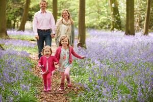
That means places with the finest bluebell displays, the best newly-green woodlands, the most dramatic scenery. The result is 30 great routes that criss-cross the country, including Northern Ireland.
There are trails here for families with toddlers or buggies, for those looking for a good stretch, and for serious hikers wanting to blow the cobwebs out of their hair after the long dark winter.
Each walk listed includes the distance and the time it takes to complete at a moderate pace, as well as directions to the start point. Most of the routes can be covered without maps, but we have included references to where maps or guides can be found for those trickier trails.
Of course, the usual rules apply – wear a pair of broken-in shoes or boots, waterproof gear if the weather is looking dodgy, pack a protein snack and water, charge your mobile phone, and always let someone know if you’re setting off on one of the more strenuous hikes.
And the new rules: try avoid popular spots if you’re worried about crowds and want to keep your distance. Now, let’s be having you.
By Helen Fairbairn
1. Best blueway
Where The Royal Canal Way, Castleknock, Dublin 15 to Leixlip, Co Kildare
What With your back to Castleknock railway station, turn left and join the canal towpath. Soon you reach the Deep Sinking, a narrow limestone cut where the path rises 10m above the water. Back in the 19th Century this section sometimes proved fatal for draught horses towing barges through the chasm below. The path is rough underfoot here, but a smooth, newly-resurfaced trail takes over from Clonsilla onwards. The landscape grows more rural now, with fields bordering the path. Five bridges mark your progress towards Leixlip, where the Ryewater Aquaduct carries the canal over the river Rye. This took six years to build in the 1790s. Around 500m later, cross a road bridge to reach Leixlip’s Louisa Bridge railway station.
Start/Finish Start at Castleknock railway station and finish at Leixlip’s Louisa Bridge station.
Getting there This is a linear walk, but frequent trains take just 13 minutes to run between the two stations.
Level Easy to moderate – flat towpath, largely surfaced makes this a good route with small children.
Length /Time 10km / 3 hours
2. Best for high forest trails (and buggies)
Where Cruagh Wood, Dublin Mountains
What This route is accessible to everybody, including children in buggies, but still reaches 450m high and offers fabulous views over Dublin city. There are several signed walks here, but the best circuit is the Sli na Slainte trail. This makes a relatively straightforward loop from the car park, following forest tracks and surfaced paths throughout. The trail is surrounded by pine trees and includes a gentle climb and descent of 100m. Where the trees allow, fabulous views extend over the Dublin Mountains, the city and the east coast.
Start/Finish At Cruagh Wood car park.
Getting there Exit the M50 at junction 12, then navigate south to the R115 Old Military Road. Turn left off this on to Cruagh Road, signed to Glencullen. The forest entrance is 1km later on the right. It closes at 5pm.
Level Easy to moderate – signed, surfaced woodland trails with 100m ascent.
Length /Time 5km / 2 hours
Pack A natural treasure-hunt list to encourage kids to investigate the forest.
3. Best for city views
View over South Dublin from the Dublin Mountains. Photo: Rob Durston/Fáilte Ireland
Photo: Rob Durston/Fáilte Ireland
Where Fairy Castle Loop, Dublin Mountains, Dublin 18
What It should be mandatory for every Dubliner to visit 536m Fairy Castle to gain a whole new perspective over the metropolis below. The route to the top is straightforward, with constructed paths and frequent signs to aid navigation. An initial road climb brings you to the massive communication masts on Three Rock Mountain. Now turn right alongside a forest, and climb across open mountainside to the summit of Two Rock Mountain, crowned by the massive megalithic tomb known as Fairy Castle. The incredible panorama extends from the Wicklow Mountains in the south to the Mourne Mountains in the north. Descend along the ridge, then follow signed paths and tracks back to the start.
Start/Finish At Ticknock Forest trailhead.
Getting there From Ticknock Forest entrance, drive uphill, looking for a track on the right with adjacent map board. Park in the nearby lay-bys.
Level Moderate to difficult – signed paths with 230m ascent.
Length / Time 6km / 2.5 hours
Pack Helen Fairbairn’s Dublin & Wicklow: A Walking Guide; and a flask of tea to celebrate your arrival.
4. Best for coastal views

Bray Head — climb up and over to enjoy the view
Where Bray Head Loop, Bray, Co Wicklow
What Join the Bray-Greystones coastal path at the eastern end of the car park, and turn right. Just 20m later, turn right again up a set of concrete steps. Climb straight ahead, through a patch of woodland, to a large concrete cross at 197m. There are wonderful views here across Killiney Bay to Howth. Continue south now, closing the gates behind you, to follow a path that climbs to a trig pillar at 240m. Shortly before the pillar, turn left on to a path that descends southeast through a gate across rock and grass. Turn left to join the paved coastal path, and left for 2km to return to the car park.
Start/Finish At Bray Head car park.
Getting there The car park lies at the end of Raheen Park, in southeast Bray. Alternatively, start and finish at Bray railway station, walking south along the promenade to reach the car park.
Level Moderate to difficult – unsigned mountain trails and constructed coastal path, with 295m ascent.
Length /Time 7km / 2.5 hours
Pack Your camera – this is an immensely scenic circuit.
By Helen Fairbairn
5. Best mountain crash site
Where Annaloughan Forest, Co Louth
What This popular circuit is fully signed. It explores the lower slopes of Annaloughan Mountain and the trees of Rockmarshall Forest. The forest is a mixture of deciduous and pine trees, with patches of bluebells and wood anemone in spring. Open sections also offer fabulous views over Dundalk Bay and Slieve Foye. Begin by following the purple arrows east along the road, then turn left onto a lane. This leads to a series of tracks and paths that loop around the hillside. Once out on open mountain terrain, a short detour brings you to the site of a 1942 plane crash, where metal wreckage still lies on the ground.
Start/Finish At Fitzpatrick’s Bar and Restaurant, Rockmarshall, Dundalk.
Getting there Exit the M1 at junction 18, then follow the R173 towards Carlingford. You’ll reach Fitzpatrick’s Bar after 7km.
Level Moderate – signed tracks and paths with 230m ascent.
Length /Time 8.5km / 3 hours
Pack A copy of Adrian Hendroff’s book, The Mourne and Cooley Mountains: A Walking Guide.
6. Best for beachcombers
Where Clogherhead Coastal Walk, Co Louth
What This circuit may be short, but it explores a fascinating section of coastline, with views stretching from the Mourne Mountains to Lambay Island. From the beach car park, head back along the road for 100m. Turn right at a junction, then left along a lane. At the next T-junction, turn right and continue for 1km to the large harbour of Port Oriel at the end of the road. Turn right here and follow a series of low cliffs around the headland and back to the beach. Archaeologists believe these coastal outcrops provided several rock slabs used in the construction of Newgrange and other tombs in nearby Boyne Valley. If you want more distance, continue as far as you like along the beach itself.
Start /Finish At Clogherhead Beach car park.
Getting there From Drogheda, follow the R166 northeast to Clogherhead village. In the village centre, follow signs for the Lifeboat Station.
Level Easy to moderate – unsigned tarmac lanes and coastal paths.
Length /Time 3km / 1.5 hours.
7. Best for spring flowers
Carpets of bluebells bloom in spring at Killinthomas and at Moore Abbey
Where Killinthomas Woods, Co Kildare
What This beautiful deciduous woodland features one of the country’s best carpets of bluebell and wild garlic during the month of May. Primrose and celandine also find shelter beneath the lime-green leaves of the mature beech trees, and it’s impossible to come here in spring without leaving uplifted and refreshed. Choose from 10km of signed walking routes, all of which start and finish at the car park. There are options for both long and short outings, with the ‘Camp Walk’ and ‘Bluebell Walk’ both accessible to wheelchairs and buggies.
Start/Finish At Killinthomas Woods car park.
Getting there From the centre of Rathangan town, take the R401 towards Edenderry. Turn right at a roundabout onto the L3001, then look for a right turn signed to the ‘Woods’.
Level Easy to moderate – largely flat, signed woodland paths.
Length /Time Up to 10km / 3 hours
Pack A wildflower book for identifying the species you see.
8. Best for history buffs
Where Moore Abbey, Co Kildare
What When a woodland has a walking trail called the Bluebell Way, you can guarantee it’ll be pretty in spring. This particular trail follows a cypress-lined avenue, and radiates colour when the bluebells are in flower. This is one of three short, signed routes in the forest beside Moore Abbey; complete each walk separately, or mix-and-match them to make a longer outing. The trees are a mixture of conifer and broadleaf species, while the abbey occupies the site of a former monastery, first founded by St Evin in the 5th Century. The current building dates from the 1760s.
Start/ Finish At Moore Abbey forest car park.
Getting there Exit the M7 at junction 14, then follow the R445 towards Monasterevin. Take the first left onto the R427 towards Athy; the forest is on the right, 1km later.
Level Easy – flat and signed woodland trails.
Length /Time Up to 4km / 1.5 hours
Pack A camera to capture the beauty of the flowers.
9. Best for playing at High King of Ireland
Where The Ridge of Cappard, Co Laois
What Beautiful Glenbarrow is the most popular of the Slieve Bloom glens. This route explores the base of this glacial valley, then climbs onto the enclosing mountainside to the Ridge of Cappard. There are five marked walks here, and this route is an amalgamation of many of them. Begin by following an atmospheric woodland path along the nascent River Barrow. Pass the famous triple tiers of the Clamphole Waterfall, and continue upstream to an old water mill. Now turn left and climb out of the trees, joining an elevated boardwalk on top of the ridge. Far-ranging views encompass all four provinces of Ireland. Follow walking arrows back to the start via more boardwalk and forest tracks.
Start/Finish At Glenbarrow car park.
Getting there Head to the village of Rosenallis, along the R422. Turn south opposite the church, and follow brown signposts to Glenbarrow car park.
Level Moderate – signed trails with 180m ascent.
Length /Time 10km / 3 hours
Pack The Comeragh, Galtee, Knockmealdown and Slieve Bloom Mountains: A Walking Guide, by John G O’Dwyer.
10. Best for hikers
What Scarr and Kanturk Mountains, Co Wicklow
Where This memorable route traverses a pair of mid-height peaks, providing fine views over the Wicklow Mountains. Begin by heading northwest along the road. After 1.5km you pass a bridge; 60m later, turn right through a wooden gate onto a footpath. Pass above Lough Dan, then cross a track. The path climbs a mountain shoulder to a maze of granite outcrops at the summit of Kanturk (523m). Continue southeast across a col to reach 641m Scarr, with its narrow summit ridge and fabulous views. To descend, head south to a forest track, then turn left onto a road that carries you back to Oldbridge.
Start/Finish At a lay-by in Oldbridge.
Getting there From the hamlet of Oldbridge, turn north, following signs to Lough Dan. Park 250m later in a large lay-by on the left.
Level Difficult – unsigned mountain paths and 540m ascent.
Length /Time 14km /4.5 hours
Pack Detailed route notes from Helen Fairbairn’s Dublin & Wicklow: A Walking Guide.
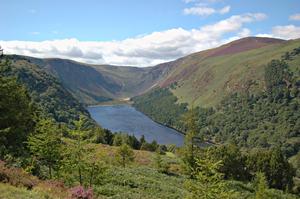
11. Best for a taste of monastic life
Climb up past the monastic settlement at Glendalough
What Derrybawn Woodland Trail, Glendalough, Co Wicklow
Where This circuit explores Glendalough’s prized oak woods, and is particularly beautiful in spring when bluebells and other wildflowers are in bloom. The walk is signed throughout by orange arrows. From the southwest corner of the car park, cross a footbridge and turn right onto the wide trail known as the Green Road. After 200m, another footbridge offers access to the 6th Century monastic city, which is well worth a detour. Then continue along the Green Road to the park information office. Turn left here, climbing a series of steep steps beside Pollanass Waterfall. Follow a high forest road across the slopes of Derrybawn Mountain, before dropping back to the Green Road and returning through mature oak trees to the start.
Start/Finish At Wicklow National Park Visitor Centre car park
Getting there The visitor centre is located roughly 3km west of Laragh village, along the R757.
Level Moderate – signed woodland trail with 160m ascent.
Length /Time 8km / 2.5 hours
Pack ‘The Walking Trails of Glendalough’ leaflet, available from the visitor centre or wicklowmountainsnationalpark.ie
12. Best for tree lovers
Where Clogrennan Wood, Co Carlow
What This woodland is relatively old by Irish standards, with forest cover stretching back to the 1800s. Today it is home to various tree species, including beech, spruce, larch and oak, with spring flowers including bluebells, wild garlic and herb robert. A signed loop walk begins from the car park and explores a series of forest tracks. It’s short enough to appeal to families, and a section of open, hillside path allows long views across the Carlow countryside to the Wicklow and Blackstairs Mountains. Follow the purple arrows throughout to stick to the main path, or divert off onto a host of meandering side trails.
Start/Finish At Clogrennan Wood car park.
Getting there Exit the M9 at junction 6, then follow Google map directions to Clogrennane Lime Ltd. The forest car park is 400m west of the lime works.
Level Easy – flat, signed woodland tracks.
Length /Time 4km / 1.5 hours
Pack A phone loaded with Google maps to find the start.
13. Best for waterside walkers
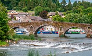
Go with the flow: The River Barrow in Graignamanagh
Where The Barrow Towpath, Graiguenamanagh to St Mullins, Co Carlow
What This out-and-back route follows a tranquil towpath along the banks of a verdant waterway, pausing for lunch in the pretty and historic hamlet of St Mullins. The walk forms the final section of the 114km-long Barrow Way, but you join the route on the eastern side of Graiguenamanagh’s seven-arch bridge. From here, head downstream along a lane that soon turns into a footpath. Navigation is straightforward; simply follow the river bank all the way to St Mullins. Along the way you encounter four locks, and pass through deciduous woodland and a steep-sided valley. In St Mullins, the riverside buildings were once a water-powered mill. Then detour 400m up the road to visit an atmospheric old monastery and adjacent Norman motte, before returning to Graiguenamanagh.
Start/Finish At Graiguenamanagh.
Getting there Graiguenamanagh is located along the R703, 23km southeast of Kilkenny.
Level Easy to moderate – flat riverside path.
Length /Time 12km / 4 hours
By John G O’Dwyer
14. Best for nature lovers
Where Lough Avalla Farm Loop, Co Clare
What A varied outing through an abundance of natural habitats which starts from Mullaghmore Crossroads. Here, a green lane leads towards the Jeuken family organic farm before it dives right into a hazel forest and passes a holy well. Upwards then to spectacular limestone karstlands, which in late spring and summer are a profusion of wild flowers. Fractured limestone benches now lead to a Neolithic burial cairn offering super vistas over the Burren landscape. As the trail gallops east beneath some immense cliffs, your eyes are drawn to the scene-stealing contours of limestone on Mullaghmore – the aptly titled, Queen of the Burren. The route then traverses timeless farmlands before decanting you back at the Jeuken farmyard.
Getting there From the village of Corofin, take the Kilfenora road, turn right at Killinaboy, pass a school and continue to the trailhead, where there is parking.
Start / Finish Mullaghmore crossroads.
Level Easy – ideal for those who enjoy easy rambling.
Length / Time 6km / 2.5 hours
Pack Fleece and raingear, walking poles are useful; but leave the dog behind – this is a mutt-free route.
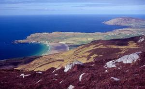
15. Best for dramatic views
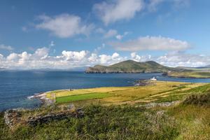
Dramatic views over Valentia Island
Where Cnoc na dTobar, Co Kerry
What If you love spectacular views, this one is for you. The mountain has been a sacred site since pagan times when the ancient Lughnasa Festival was celebrated on its summit. The trail starts near sublime Coonana Harbour and meanders uphill with great views constantly unfolding. The easy-to-follow path is marked by 14 Stations of the Cross, leading to an imposing Celtic cross on the summit. Here, a majestic 360-degree vista radiates over the Atlantic Ocean, Skellig Rocks, Valentia Island, West Cork, Carrauntoohil, the Blasket islands, the Dingle peninsula and back to MacGillycuddy Reeks. Arguably this is Ireland’s finest mountaintop viewing point. Descend by your route of ascent.
Start / Finish At the Coonanna car park.
Getting there Leave the N70 Ring of Kerry road to cross the bridge in Cahersiveen. Take the first right and second left, signposted Coonana Harbour. Pass St Fursey’s Well and begin from the parking beyond.
Level Hard – best for seasoned walkers.
Length / Time 9km / 3 hours
Pack Warm clothing, raingear, packed lunch and OS Discovery Sheet 83. Walking poles are useful for your descent.
16. Best for pilgrims
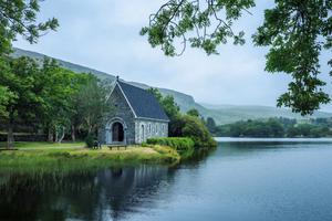
St Finbarr’s Oratory, Gougane Barra
Where St Finbarr’s Pilgrim Path, Co Cork
What If you are a fit hillwalker who loves connecting with the past, then one of Ireland’s oldest pilgrim trails offers an excellent but strenuous outing that is fully waymarked. Genuinely unforgettable, it offers a huge variety of terrain and many memorable vistas. From Kealkill, the waymarkers lead in fine style first over the lovely viewing point of Knockbreteen Hill, onwards then through the isolated Maughra Valley before gaining the Sheehy Mountain plateau beside lonely Lough Fada. Your pièce de résistance comes in the form of a glorious descent into the embrace of the Gougane Barra Valley.
Start Carriganass Castle, Kealkill, Co Cork
Finish St Finbarr’s Oratory, Gougane Barra
Getting there From Cork city take the N22 for Macroom. Follow the R585 through Crookstown to Kealkill.
Level Hard – suitable for fit and experienced walkers.
Length / Time 18km / 7 hours
Pack OS Discovery Map 85 and a compass, as well as warm clothing, raingear, packed lunch, walking poles, mobile phone.
17. Best for strollers and whale watchers
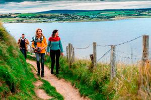
Ardmore Cliff Walk in Waterford
Where Ardmore Cliff Path, Co Waterford
What An undemanding outing for coastal views that are truly spectacular. There is a genuine sense of reconnecting with history while something new seems to crop up around every corner. Out to sea, there’s always the chance of a whale sighting. From the trailhead, walk uphill to the Cliff House Hotel and on past the early Christian church and well of St Declan. Beyond, the cliff-top path meanders spectacularly around Ardmore Head with great declivities falling to the left until the wreck of the Sampson crane ship comes into view. It was lost in a 1988 storm and has now become a visitor attraction. After rounding Ram Head, you will be rewarded with an outrageously photogenic vista over Youghal Bay and the east Cork coastline. Then it’s inland to explore St Declan’s Monastery. Occupying a striking hilltop setting, the most prominent landmarks are the 30m-high round tower and the now roofless cathedral. Afterwards, it is a short ramble downhill to the trailhead.
Start / Finish Ardmore Church, Ardmore village.
Getting there From the N25 (the main Cork to Waterford Road), take the R673 south to Ardmore.
Level Easy – ideal for casual strollers.
Length / Time 4.5 km/ about 1 hour
Pack A jacket, and OS Discovery Series sheet 82 (though you won’t really need it).
18. Best for families
Where The Millennium Stone Loop, Co Tipperary
What Despite rampant globalisation, there are still places far removed from our tourism honeypots where life moves at a gentler pace and, as such, the Millennium Loop makes a splendid outing for all the family. Your exploration begins from Aherlow House Hotel car park and heads uphill, crossing a public road. Walking arrows now point to the outcrop at Rock an Thorabh offering magnificent views of Tipperary and the Slieve Felim Mountains beyond. Continue to a minor road and turn right to reach the Millennium Stone, which was dug from a nearby hillside and depicts the life of Christ. Then follow the arrows along quiet sylvan trails to the great Galtee Mountain viewing point at Christ the King statue. Return to the hotel along a serene nature trail through sublime mixed woodland.
Start / Finish Aherlow House Hotel, Newtown, Co Tipperary.
Getting there From Tipperary town take the R664 south. After negotiating a couple of hairpin bends, Aherlow House Hotel is signposted right.
Level Suitable for families.
Length / Time 9km/ 3 hours
Pack A jacket and OS sheet 66.
By Adrian Hendroff
19 Best for bluebells and sunset
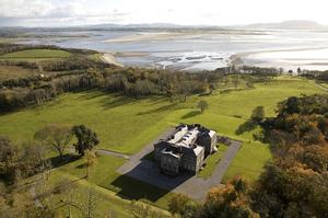
Lissadell House, Sligo
Where Lissadell Woods and Strand, Co Sligo
What A pleasant linear walk along a wooded path running between a road and Drumcliff Bay. The walk is located within the boundary of the Lissadell Estate, which was once owned by the Gore-Booth family. Constance Gore-Booth, better known as Countess Markievicz, was an Irish revolutionary who participated in the 1916 Easter Rising. Two years later, she became the first woman to be elected to the House of Commons at Westminster. The woods here are decorated with a carpet of blue and white when bluebells and wild garlic bloom in the spring. The path later continues along the sheltered Lissadell strand where you can enjoy splendid views south to Knocknarea or photograph a stunning Wild Atlantic Way sunset. Look out for seals bobbing in the bay or barnacle geese flying overhead.
Start / Finish Car park at a lay-by at Lissadell Strand.
Getting there From Sligo, drive northward along the N15 toward Drumcliff. After the village, turn left into a road signposted Carney. From there, turn left at a junction for Lissadell. After around 2km, turn left into a minor lane towards Lissadell Strand. Reach the parking spot after about 1km.
Level Easy – suitable for all.
Length /Time 3km / 1 hour with plenty of time for stops.
Pack Trainers, camera, hot flask and some snacks.
20. Best for moorland and country views
The broad expanse of Lough Allen in Leitrim
Where Slieve Anierin, Co Leitrim
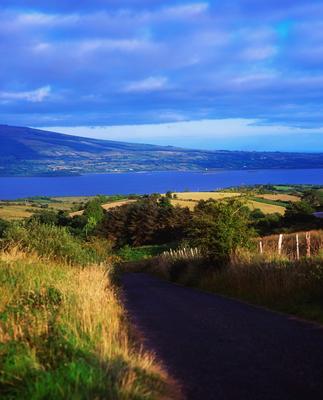
What Slieve Anierin is a broad mountain plateau to the east of the massive Lough Allen. The mountain’s Irish name, Sliabh an Iarainn or ‘mountain of iron’ stems from primitive mines in the area celebrated for iron ore and coal. From the post office, follow a small lane with a Yellow Man signpost leading uphill. This leads to a grassy mountain track at an access gate near a concrete plaque. The track later dwindles, but continue to climb until reaching the top of the plateau. Enjoy fine views of cliffs that line up the eastern end of the plateau as you ascend. A dry, clear day helps as the summit area is quite featureless and boggy. A concrete plinth with a rusted metal disc marks the 585m top. Extensive views of the Leitrim countryside to the east – best at sunrise – feature prominently during the walk. Look out for white-flowered blackthorn in the spring.
Start /Finish Aghacashel Post Office.
Getting there From Drumshanbo, drive northeast along a minor road for around 8km to reach Aghacashel. There are parking spaces near the post office.
Level Moderate – best for seasoned hikers.
Length / Time 6.5km / 3 hours
Pack Good walking boots, a copy of Adrian Hendroff’s Donegal, Sligo & Leitrim guidebook and a map (OS Discovery Series 26).
21. Best for wildlife
Where Kilronan Castle Woodland Trail, Co Roscommon
What A lovely walk through Kilronan Forest along the northern shore of Lough Meelagh. Follow red markers along woodland and lakeside paths as far as Doon Point on the western fringes of the lake. Daffodils and bluebells carpet the ground in the spring. Look out for deer, foxes, hares and squirrels in the woods; also birds such as the greenfinch, song thrush, robin, blue tit and sparrowhawk. The lake is idyllic on a clear day or atmospheric with a bit of mist and the sun trying to break through. Kids will like the swans flitting along the water.
Start / Finish Kilronan Castle car park
Getting there Follow the N4 towards Sligo. Around 6km past Carrick-on-Shannon, turn left into the R285 signposted Knockvicar and Keadew. Reach a junction after around 10km and turn left here toward Ballyfarnon. The entrance into Kilronan Castle is located 1.5km on the left.
Level Easy – ideal for families with kids.
Length/Time 4.5km / 1.5 hours
Pack Comfortable walking shoes and the route description/map on irishtrails.ie or ask at the hotel reception for details.
22 Best for that ‘edge of the world’ feel
Where Benwee Head, Co Mayo
What Perhaps the finest stretch of cliff scenery in the country. At 255m, it is higher than the Cliffs of Moher. From April, pink sea-thrift can be found lining the cliff-tops. Begin from the Children of Lir sculpture, perched at the top of a beautiful inlet surrounded by 100m-high cliffs. Head east, cross a stream and follow the cliff-line (do not step too close to the edge) to reach the 255m summit. Descend 1.5km northeast to a cliff-top overlooking a dramatic bay enclosed by an arc of majestic cliffs and the Stags of Broadhaven. From here, retrace your steps back to the start. This can be quite enjoyable as the scenery looks different going in the opposite direction, giving prolonged views of Kid Island (Oileán Mionnán), the Mullet peninsula and Achill Island. Look out for gulls, fulmars, guillemots, razorbills and kittiwakes.
Start / Finish Benwee Head ‘An Bhinn Bhuí’ car park.
Getting there From Belmullet, take the R313 then the R314 to Glenamoy. Follow signs north off the R314 from Glenamoy to Carrowteige (signposted An Ceathrú Thaidhg as this is Gaeltacht country). Pass through the village, continue straight and uphill at a crossroads about 1km further. Reach a T-junction as the road begins to descend. Turn right and follow a narrow lane north towards a lay-by at the coast.
Level Moderate – suits regular hikers.
Length/Time 7 km / 2.5 hours but leave time for photo stops.
Pack A camera and map (OS Discovery Series 22).
By Helen Fairbairn
23. Best for northern bluebells
Where Portglenone Forest, Co Antrim
What Though a relatively small woodland at 65 acres, Portglenone is one of the finest places in Northern Ireland to see spring bluebells. It even holds its own Bluebell Festival each year. The broadleaf trees are classified as Ancient Woodland, and this is a remnant of a great primeval forest that once extended to the Sperrin Mountains. As well as bluebells, wild garlic and wood anemone cloak the forest floor. There are several walking paths, but the main route is a circular loop signed by red markers. It follows largely level trails, visits the memorial grove of horticultural hero Augustine Henry, and includes a waterside section along the banks of the River Bann.
Start/Finish At Portglenone Forest car park.
Getting there From the centre of Portglenone, follow the A42 south towards Ballymena. The forest entrance is 1.5km later on the right, and there’s a parking charge of £4 per car.
Level Easy – largely flat, unsurfaced woodland paths.
Length/Time 2km / 1 hour
Pack Your macro lens for close-up shots of the flowers.
24. Best for mountain lakes
Jaw-dropping views from the Urris Hills, Inishowen Peninsula. Photo: garethmccormack.com
Where Urris Lakes Loop, Co Donegal
What This beautiful hillwalk visits two secluded lakes on the northern slopes of the Urris Hills, on the Inishowen Peninsula. Starting from a remote, sandy beach, the route is fully signed by purple arrows, and follows a series of tracks and paths across open mountainside. An ascent through a broad gully takes you first to Crunlough, a circular gem of a lake tucked beneath rugged and brooding slopes. A rocky ridge then carries you past the long, narrow waters of Lough Fad. There are excellent views throughout, both across the north Donegal coastline and inland to the Derryveagh Mountains.
Start/Finish At Leenankeel Beach parking area.
Getting there From Buncrana, follow Wild Atlantic Way signs north over Mamore Gap. At the bottom of the gap turn left at a crossroads. The beach parking area is on the left after 1km.
Level Moderate to difficult – signed mountain trails with 340m ascent.
Length/Time 7km / 2 hours
Pack More route details from Ireland’s Wild Atlantic Way: A Walking Guide, by Helen Fairbairn.
25. Best mountain ascent
Where Muckish Mountain, Co Donegal
What The distinctive, flat-topped form of 667m Muckish is a natural icon of north Donegal. The mountain’s towering cliffs contain quartzite deposits that were mined commercially until 1955. This route begins at the bottom of the old mine, then follows the former Miners’ Track on a precipitous ascent up the rock buttresses. Exposure and loose stones mean care is required throughout. Pass under the lip of the upper quarry basin, then make a sudden exit onto the summit plateau. The summit cairn and trig point lie a short distance northeast, with impressive views encompassing both the wild coastline and surrounding Derryveagh Mountains. Carefully reverse your outward route to return to the start.
Start/Finish A lay-by on the northern side of Muckish
Getting there From Creeslough village, follow the N56 north. Around 2km later, turn west towards Derryharriff. Keep left over a cattle grid and park in a stony clearing about 80m before the end of this road.
Level Difficult – steep, unsigned mountain paths with 400m ascent
Length/Time 4.5km / 2 hours
Pack Your hiking boots and a head for heights.
This feature originally appeared in The Sunday Independent.